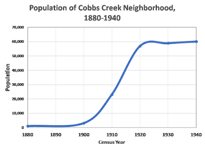
A lot has been written about the history of West Philadelphia. However, there is almost nothing written about the Cobbs Creek neighborhood. Its sits at the far western edge of Philadelphia from 52nd St. to the Cobbs Creek Parkway (63rd St.) and from Market St. to Baltimore Ave. By 1940, it had a population of 58,400, 19% of the population of West Philadelphia.
In 1880, almost all of Cobbs Creek was farms and large estates. A single census district counted a population of only 1, 641 including many in areas just below Baltimore Ave. The population was not evenly distributed. 611 people lived in the West End area around the West End Mill (1). Others lived around the Angora Mill and Hoffman's Mill that were just below Baltimore Ave. The area did not yet have the rectangular street grid that was proposed in 1860 and house did not have street addresses. Instead the census gave only vague geographic locations. These included a small number of houses along major roads that no longer exists: Marshall Rd., Gray's Lane, and Rabbit Lane .
 |
| Click to expand maps. |
In 1900, the neighborhood between Market St. and Baltimore Ave. still had a population of only 745. The Bromely Atlas for 1892 shows the same distribution of houses.
The population began expanding rapidly after the opening of the Market St. Elevated in 1907. By 1910, it reach 24,568 and doubled by 1920 to 56,960.
This expansion was possible because of the construction of thousands of row homes. This required the paving of the street grid, and laying water and sewer lines.
Aerial photo of the Cobbs Creek area looking east. The
area that became Cobbs Creek Park is at the bottom
The road at the lower left is what was left of Marshall Rd.
(Temple University Archives)
In 1920, the area was 99% White with 21% of the adults foreign-born. The largest immigrant groups were those born in Russia (8%) and Ireland (4%). In some areas west of 59th St. and north of Cedar more than 20% of adults were Jews born in Russia who reported speaking Yiddish. Most of them were born in the Ukraine and other eastern parts of the Russian Empire.
In some areas to the east of 59th St. and south of Cedar, more than 20% of adults were born in Ireland or were the children of Irish immigrants.
In 1940, 13% of adults were born in Russia. Most of them spoke Yiddish. The majority lived west of 57th St.
In 1930, Cobbs Creek had a population of 60,220. The Black population only accounted for 1.8% . Blacks were concentrated near Market St. across from the largely Black neighborhoods of Haddington and Mill Creek. In one census district in Cobbs Creek (ED 504), 19% of the population was Black.
Following the Second World War, the population of Cobbs Creek, and all of Philadelphia changed very rapidly, Many factors helped to promoted "White flight." Deed restrictions that prevented selling properties to Nonwhites became illegal The opening of the Schuylkill Expressway and the Walt Whitman Bridge facilitated commuter access to the Main Line and New Jersey. Fueled by racist fears and increased family sizes during the Baby Boom young families rushed to new suburbs.. In 1950, Cobbs Creek's population was 97% White. By 1960, this dropped to 37% and by 1970, it was only 6%. The population remains almost 100% Nonwhite.
In summary, the population of Cobbs Creek experienced two periods of very rapid change. First, the sparsely populated area of farms and estates erupted into a 20 year period of explosive growth. The new residents were almost all White with many residents foreign-born. Second, the period from 1950 to 1970 saw the White population decline by 94%. The Black population increased from only a few thousand to almost 50,000 - enough to keep the total population almost unchanged and create the neighborhood we know today.
(1) The story of the West End Mill and the people who worked there is available at the West Philadelphia Collaborative History site: The Boothroyd and Goodyear Families of Mill Workers and the West End Mill.


